


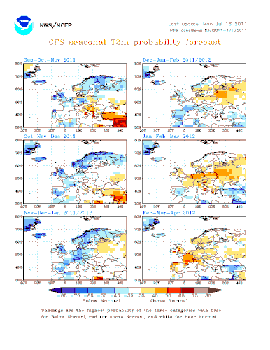
Les premières tendances saisonnières qui se dégagent pour l'automne et l'hiver 2011 / 2012 sont cohérentes avec le cycle actuel de la fin de la Nina et de la persistance d'une période neutre pour l'hiver. La reprise d'un faible El Nino n'est pas exclue.
L'Europe va certainement renouer avec un hiver plus doux que les précédents, après un automne assez froid. Le scénario global semble être le suivant:
- un automne devenant très frais et encore assez sec, sauf sur le pourtour méditerranéen en septembre, en attendant le retour des perturbations océaniques en octobre pour les régions septentrionales.
- Le mois de novembre pourrait s'avérer relativement froid et assez sec, avant l'établissement d'un temps plus perturbé en décembre : flux océanique d'ouest, avec davantage de précipitations sur les pays de l'Europe du Nord (ainsi que le nord de la France) et l'installation d'un temps sec sur les pays du sud (ce qui inclu la moitié sud de la France).
Dans ce cas de figure, la recharge hydrique efficace automnale serait alors assez faible, et l'enneigement en montagne pourrait être très déficitaire.
----->
The first seasonal trends that emerge for autumn and winter 2011 / 2012 are consistent with the current end of the Nina and the persistence of a neutral for the winter period. The recovery of a weak El Nino is not excluded.
Europe will certainly revive a much milder winter than the previous, after a cold autumn. The overall scenario appears to be:
- A cold autumn and still quite dry, except in the Mediterranean in September, pending the return of ocean disturbances in October for the northern regions.
- The month of November may be relatively cold and dry enough, before the establishment of a troubled weather on December: ocean flows from west, with more precipitation on the countries of northern Europe (and the northern France) and the installation of dry weather on the southern (which includes the southern half of France).
In this case, the recharge water would be effective fall quite low, and snow in the mountains could be very negative.


