


The Northern Hemisphere is in the midst of one of the strongest December La Niñas ever observed. This comes as a surprise to some, considering 2010 tied 2005 for the warmest year on record, as reported by NASA on Wednesday.
Additionally, AccuWeather.com Chief Long Range Forecaster Joe Bastardi has noted that worldwide temperatures December into January are below normal.
During a typical La Niña pattern, the ocean waters of the equatorial central and eastern Pacific are much cooler than normal, and in turn have significant effects on the weather pattern in the United States and around the world.

This graphic shows what typically occurs during a La Niña pattern. Not all weather events this winter have correlated with this pattern.
However, while some extreme weather events over the past year were reflective of what usually occurs during a La Niña pattern, some were not.
La Niña patterns can lead to increased precipitation and tropical activity in Australia and Southeast Asia. A tropical cyclone contributed to extreme rainfall in Australia, which led to disastrous flooding in Queensland.
"The copious rainfall is a direct result of La Niña's effect on the Pacific trade winds and has made tropical Australia particularly rainy this year," David Adamec, a NASA oceanographer, said in Wednesday's report.
Other events coinciding with the La Niña include the extreme cold the United Kingdom experienced last month.
The U.K.'s snowy December was the coldest on record.
Other worldwide weather events are very uncharacteristic of a La Niña pattern.
During a La Niña winter, the jet stream across the United States typically shifts northward, bringing wet weather to the Pacific Northwest, while giving the southern half of the country a dry, mild season.
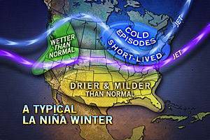
This graphic shows a typical La Niña winter in North America. So far this year, flooding on the West Coast, winter storms in the South, and extended cold in the Northeast all go against this pattern.
Heavy rain and thunderstorms led to extreme flooding in California and Utah in December.
The United States had its share of cold so far this winter. Most of the East Coast was much colder than normal in December, with the Southeast having the most significant departures from normal.
A storm that eventually dumped more snow on the Northeast began as a severe ice storm in the South, turning roads into sheets of ice.
Despite these uncharacteristic La Niña weather events, the pattern will likely not be changing anytime soon.
"La Niña is expected to continue well into the Northern Hemisphere spring 2011," according to Wednesday's report.
AccuWeather.com meteorologists think the La Niña pattern will last well into summer, or perhaps even into early fall.
"If the La Niña lasts into fall, it will likely continue into next winter," said AccuWeather.com Senior Meteorologist Dale Mohler.
BrokerMeteorology


