


Europe / France: arrival of the cold end of January
The cooling trend of the European continent is gradually with the accumulation of cold air associated with the Siberian anticyclone. The cold settled so late on Russia, including diving to the Black Sea and Turkey snowstorms and low temperatures (up to -34 ° C) relate to the area.
In contrast, the extension of cold air eastward from Russia to northern Japan caused intense snowfall, especially on the island of Hokkaido.
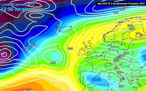
The envisaged is: the end of January and especially in the first decade of February, the cold air should invade continental Western Europe to France. If some snowfall in the plains are possible in the flow is, it is usually a dry cold. In the Mediterranean, the advection of cold air triggers instability and it may snow at very low altitude coastal areas of south-eastern France, Italy, the Balkans and in the interior of the Algeria and Tunisia.
This configuration of an auspicious month of February probably cold enough in France, consolidating our recent seasonal forecasts.


